
EAST CENTRAL MINNESOTA & THE ST. CROIX BORDERLANDS
River roads.
Living stories.
The places we call home have a story.
Railway towns that moved. Immigrant traditions that stayed. Rivers, ballparks, museums, and gathering places that still bring people together.
Follow a chapter or choose a numbered place on the map.
BEFORE THE TOWN LINES
A landscape already
full of history.
The boundaries on this map show today’s community geography. They do not describe Indigenous territories or the extent of earlier settlements.
THE STORY CONTINUES
Memory has
a local address.
A family photograph, a church ledger, a remembered Main Street, or a working piece of farm machinery can make a place’s history tangible. Spark House helps gather and preserve the materials and memories still held by neighbors.
Contributors choose how their materials may be credited, displayed, or shared with the Isanti County Historical Society. Submissions go to Spark House for review before anything is added to this atlas.
Share stories, photos, or information Our work supporting local heritage1804–2026 · SELECTED MILESTONES
Time leaves
its mark.
See how transportation, migration, rebuilding, and community traditions changed this region. Select a milestone to locate its community.
Dates retain the precision of their sources. Year and decade ranges do not imply exact dates. Map locations identify modern communities, not the precise sites of historical events.
THE EVIDENCE BEHIND THE ATLAS
A story worth
tracing.
Each community’s history links to the local institutions, historical societies, and other references behind it. The map adds contemporary geography from the U.S. Census Bureau and USGS.
Take the story further.
The downloadable package includes the complete narratives, references, map cards, boundaries, and an ArcGIS StoryMap setup guide.
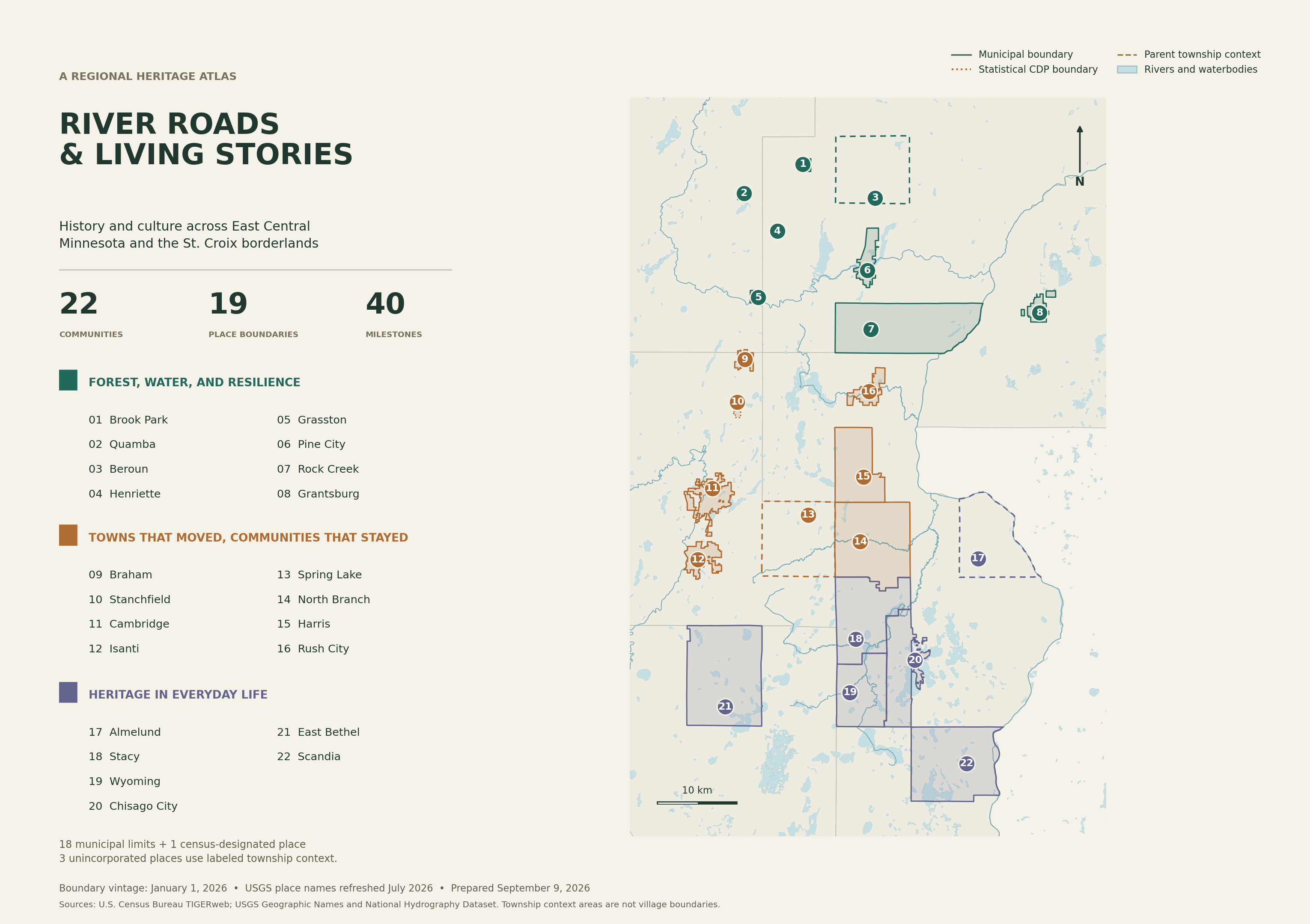
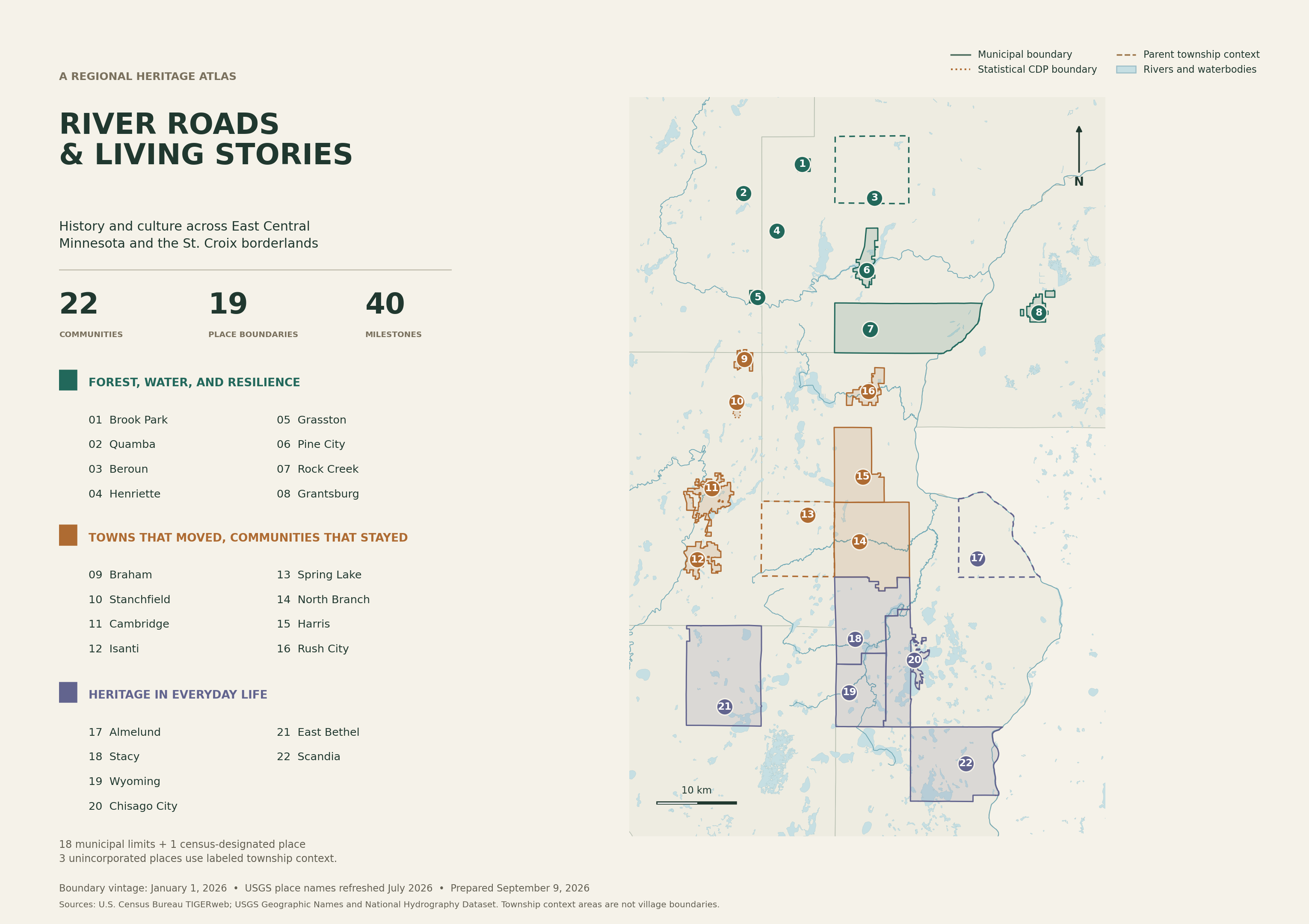
Reading the boundaries
18 municipal boundariesFull incorporated-place polygons.
Stanchfield CDPA statistical community area, distinct from the larger township.
Three township context areasMission Creek for Beroun; North Branch Township in Isanti County for Spring Lake; Amador for Almelund. These are broader areas than the named settlements.
Geography, dates, and location precision
Boundaries are full January 1, 2026 Census geographies, with detached areas and holes retained. Community display points come from USGS Gazetteer records refreshed in July 2026; they are not visitor entrances.
Rivers are selected named NHD flowlines within the regional study window. Lake polygons remain complete; the selection includes waterbodies with source area of at least 0.02 km². These layers provide regional context rather than an exhaustive drainage inventory.
Supplementary heritage sites use approximate street-address locations or mapped feature centers. Stanchfield Baptist Church’s text is retained in the dataset’s unlocated-sites table because its location was not verified.
The 22 communities follow the researched guide. Grantsburg and Scandia were likely cropped labels on the source map; their actual geographic identities are verified. One unreadable label was not assigned a place.
Editorial chapter groupings are not historical or cultural territories. This map is for interpretation, not a parcel survey or regulatory zoning determination.